Everyone knows about the primary Stonehenge solstice axis - it runs from Summer Solstice Sunrise to Winter Solstice Sunset.
Every June 21st (or thereabouts - it varies depending on leap years and other things), thousands of people turn up and spend the night in and around the monument waiting for the Sun to rise out of the Heelstone.
And every December 21st (or thereabouts), hardly anyone bothers to show up specifically to stand by the Heelstone to watch the Sun set into the centre of the monument just to the left of Stone 56 in what would have been the gap between the two uprights of the tallest trilithon had it not collapsed in antiquity.
But there's a second solstice axis, which runs from Winter Solstice Sunrise to Summer Solstice Sunset.
I first became aware of this as a result of reading Prof. Gordon Freeman's book "Canada's Stonehenge" back in 2009. In it, Gordon discusses the alignments of a First Nation's medicine wheel in Alberta and also those of Stonehenge. Gordon came to the UK to carry out observations over a number of years from the 1990s onwards, making him somewhat unusual in archaeoastronomy terms in that he actually used his own eyes on site to arrive at his conclusions instead of relying only on plans, maps and computer simulations.
In the book (2nd edition is called "Hidden Stonehenge") he pointed out that there's a direct sightline that runs through the monument on a roughly NW-SE axis which points directly at the rising point of the Sun over Coneybury Hill at Winter Solstice, and at the setting point of the Sun into Fargo Wood at Summer Solstice in the opposite direction.
Gordon had never been lucky enough to make a direct observation of the Winter Solstice Sunrise on the actual solstice due to adverse weather every time he'd visited. To combat this, he'd projected the Sun's solstice rising position based on photos he'd taken of near-Solstice risings that he had been able to observe.
Intrigued by this, I resolved to try and make some observations of my own.
The alignment towards Winter Solstice Sunrise that Gordon suggested runs on the dotted line shown in the following oblique aerial view...
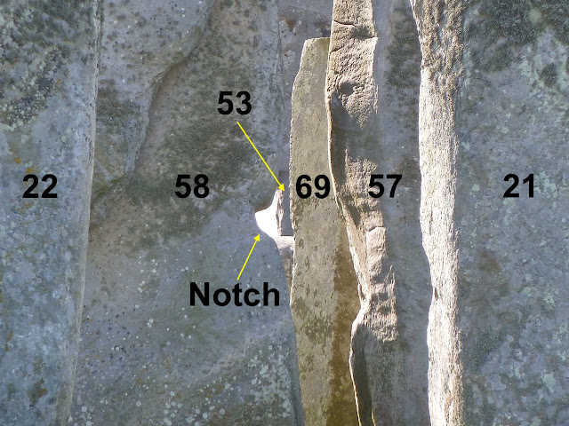
... starting from the visitor path NW of the monument, it goes via the midpoint between Stones 22 and 21 of the outer circle, then through a notch about 1.5m above the ground in the SW edge of Stone 58 of the western trilithon, skirts the NE edge of Bluestone 69 then the NE edge of Stone 53 of the SE trilithon and passes over the (now-fallen) stump of Stone 8. When S8 was originally standing, the line would have skirted its SW edge.
The view along this sightline from the visitor path is like this, with the relevant stones numbered and the notch indicated:
The closeup view (to show the Coneybury Hill horizon) is like this:
Note the very handily placed electricity pylon on the horizon for reference.
In 2011, a couple of weeks before Winter Solstice, I was able to get some photos of the rising Sun over Coneybury Hill standing on the alignment on the SE side of Stonehenge (to get an unobstructed view), which I montaged together with a wider view taken through the notch - both sets using the pylon as the reference mark.
Knowing the declination of the Sun on the 10th December, the apparent width of the solar disc and the declination the Sun would have had in 2500BC I was able to create the next image to indicate the rising position of the Sun on Winter Solstice in our era and also what it would have been when Stonehenge was built. 
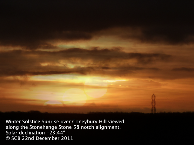
As luck would have it, on the 22nd December 2011 there was a hazy sunrise that allowed me to have some confidence my projection so far was about right.
So far so good - but what I really needed to confirm my projection was correct for our era was to get a properly clear photo of the actual Winter Solstice Sunrise - the same problem Gordon had had, and never managed to achieve.
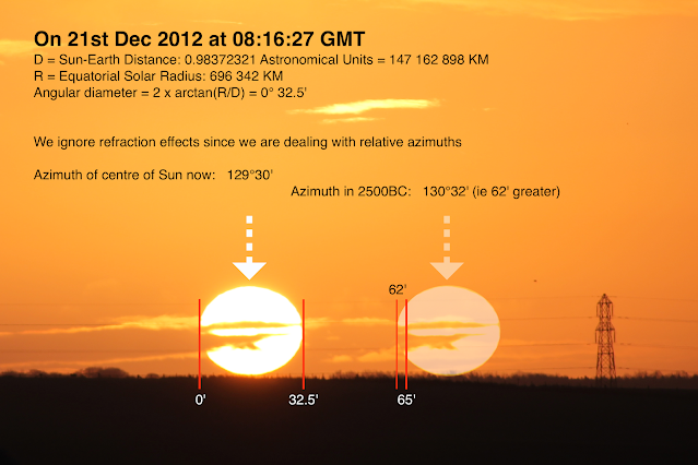
A year later, in 2012, at the Winter Solstice "Managed Open Access" event the crowd of attendees was blessed by a perfectly clear sky right to the horizon over Coneybury Hill and I was able to get the reference photo I needed (again, taken SE of the monument exactly on the alignment for an unobstructed view).
Knowing the exact azimuth of the Sun at the instant the photo was taken, and being able to calculate the azimuth that the rising Winter Solstice Sun would have had in 2500BC (when the angle of the Earth's axial tilt was 24° rather than 23.5°) I was now able to construct the equivalent view back when Stonehenge was built...
...and this (via the handy electricity pylon) then allowed me to create an updated montage of the view seen along the alignment via the notch itself, both now and in 2500BC. The alignment first identified by Prof. Gordon Freeman is targeted like a rifle sight at the precise position of Full Orb of the Winter Solstice Sunrise over Coneybury Hill when Stonehenge was built.
I'd been corresponding with Gordon since I'd first read his book, and sent him my results.
But.
There's another wrinkle.
Hidden from view in that oblique aerial photo which shows the path of the alignment through the monument is another stone. A very important stone. A unique stone. In a very specific position.
It's this one.

Not the obvious ones you can see dominating the picture - they're the collapsed parts of the tallest trilithon - I mean the one you can barely make out at the ground level, buried in the grass that starts in the lower left corner then disappears under Stone 55b before reappearing between 55b and 156 in the middle-right of the image. There are some more photos of it on my other site
The Stones of Stonehenge.
The two visible parts of it are indicated by red ellipses and the red lines show how it lies below ground. The dotted lines show that it continues under the fallen lintel Stone 156 and a further piece of it is visible at ground level just beyond (though not in this particular photo).
This is Stone 80 - aka the Altar Stone. It's a roughly 5m long by 1m wide by 0.5m thick slab of micaceous Devonian sandstone that isn't local to Wiltshire (unlike the sarsens). It's not local to the Preseli Mountains (unlike the bluestones) either. Our current best guess is that it may be from the Senni Formation of east Wales around the Brecon Beacons (although further work is ongoing to try and place its origin more securely. Update August 2024: Now confirmed that the most likely source is the Orcadian Basin spanning NE Scotland, the Moray Firth, Orkney and south Shetland: see
the Nature paper for more details).
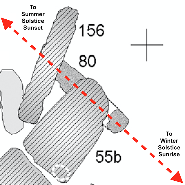
Here's a drawing showing its position in the monument. The photo above is taken roughly from where the + is, looking towards the bottom left of the diagram.
There has long been an argument about the Altar Stone - was it always on the ground, or was it knocked flat when the tallest trilithon's SE upright and its lintel fell?
I believe we can answer that question once and for all, based on Gordon's alignment. The alignment he noticed, and which I've described in detail above, runs directly along the centreline of the long axis of the Altar Stone.
Not only that, but most reconstructions and plans of Stonehenge show the Altar Stone at 90° to the primary solstice axis (the one that runs from Summer Sunrise to Winter Sunset) which is wrong. The Altar Stone is actually at 80° to that axis.
The angle between the two solstice sunrises' and the two solstice sunsets' positions, at the latitude of Stonehenge, in 2500BC - was 80°.
The primary axis and the secondary axis intersect directly over the centre of the Altar Stone.
I am convinced that the Altar Stone was deliberately placed prone and at 80° to the main solstice axis of the sarsen phase of the monument, by the builders, in order to encode the secondary solstice axis of Winter Solstice Sunrise to Summer Solstice Sunset.
There is other evidence that supports the idea that the 80° angle is not accidental. In 2014 Tim Daw wrote about the "
Twisted Trilithon" (the tallest one) of stones 55, 56 and 156 also having this angle to the primary axis, with a sightline along the SW face of 56 being aligned to the Winter Solstice Sunrise/Summer Solstice Sunset. Tim provides further evidence in his paper concerning other features of the site that share this 80° orientation.
Objectors to the secondary alignment sightline I've described above might point out that stones 57, 58 (with its notch) and their lintel 158 were re-erected in 1958 having fallen in 1797, and suggest that they might have been put back "wrongly". I dispute this - Atkinson, Stone and Bailey plus their team went to extraordinary lengths to re-seat the fallen stones correctly in their original stoneholes, even going to the effort of taking plaster casts of the bases of the stones and their stoneholes to correctly position them in their new concrete footings.
Objectors may claim that the notch is a convenient natural coincidence. I also dispute this - close inspection of it, and comparison with another notch higher up on the same edge of the same stone, suggests to me that the alignment notch shows evidence of having been tooled to smooth its natural shape into one that suits the alignment more perfectly.
Objectors might also deny that the builders of Stonehenge were at all interested in the Winter Sunrise/Summer Sunset on the basis that the entire monument has a very obvious and striking focus on the Winter Sunset direction (citing the form of the trilithon horseshoe and the impressive NE front of the sarsen circle that almost forces the viewer to want to look at things from the NE towards the SW. I do not consider that the designer of such an exquisite structure would overlook encoding the companion alignment to the obvious one we all accept, albeit in perhaps a more subtle way.
Finally, I leave you with the following images of the astonishing Bush Barrow Lozenge excavated from a bronze age barrow within sight of Stonehenge towards the southwest, whose design also captures that hallmark 80° angle of the Sun's extreme positions at the latitude of Stonehenge, and a view of the winter sunrise through Stonehenge along the secondary solstitial alignment axis.

 The alignment first identified by Prof. Gordon Freeman is targeted like a rifle sight at the precise position of Full Orb of the Winter Solstice Sunrise over Coneybury Hill when Stonehenge was built.
.png)


