Friday, September 13, 2024

The Founding Stones of Stonehenge

I was drafting a summary diagram for use in a presentation I'm giving tonight to the Hampshire Astronomical Society on the Astronomy of Stonehenge.

Building on previous work (see "Is the Altar Stone the founding stone of Stonehenge?" and "Implications of an upright Altar Stone in WA 3639"), I was working on this image:


Red lines are the Station Stone rectangle, yellow ones are the solstice axes

While labelling it up, I suddenly realised that it wasn't complete.

What's missing from this picture?

While both the solstice axes are present, aligned to Winter Solstice Sunrise <-> Summer Solstice Sunset and Summer Solstice Sunrise <-> Winter Solstice Sunset, along with the Station Stone rectangle long sides' alignments for Southernmost Major Moonrise <-> Northernmost Major Moonset, the missing element is the other Major Moonrise/Set axis.

Northernmost Major Moonrise <-> Southernmost Major Moonset axis is not represented at all - it appears as if the designers didn't incorporate this. Except... perhaps they did.

The 81° "twist" of the upright Altar Stone so you can sight along its face towards the WSSR<->SSSS directions has another effect. This is the same 81° "twist" that means it lies along that secondary solstice axis in its now prone position in front of the remains of the tallest trilithon, which also shares the same "twist" (see Tim Daw's "The Twisted Trilithon")

It causes the Altar Stone to face the missing Lunar directions.

This is a consequence of the latitude of Stonehenge, where the Northernmost Major Moonrise occurs roughly 9° further north than Summer Solstice Sunrise, and the angle between Summer and Winter Solstice Sunrises (and Sunsets) is 81°, back when the monument was constructed.

The complete diagram of all the alignments encoded with just five stones - the Station Stones and an upright Altar Stone - is this:

The Moon and Sun completely encoded with five carefully positioned stones

Once again, I'm struck by the elegance and minimalism of this structure.

To paraphrase Picasso, when he first saw the cave paintings in Lascaux, we have learned nothing in 5000 years.

Wednesday, August 28, 2024

Implications of an upright Altar Stone in WA 3639

In the previous post (Is the Altar Stone the founding stone of Stonehenge?) I wrote that perhaps Atkinson was correct when he suggested the Altar Stone might have once stood upright in the stonehole he found immediately southwest of Stone 56, the one with the Group I Cornish polished stone axe deliberately placed in its primary fill.

I went on to suggest that perhaps the Altar Stone and the Station Stones comprised the first stones on the site, as they would be the minimum that would be necessary to fix the Sky to the Earth and encode all the solar and lunar alignments.

The stonehole that Atkinson suggested is at the base of a feature catalogued as "WA 3639".


Position of WA 3639 and the suggested stonehole, from Cleal et al 1995

It's in an interesting place, being on the primary solar axis (Summer Solstice Sunrise to Winter Solstice Sunset), bang up against (and partly under) the large lumpy fragment of Stone 15, midway between Stone 56 (the tallest stone on the site, one upright of the now-fallen tallest trilithon of 55-56-156) and the massive block that is Stone 16.

I wondered if the position was at all significant in terms of the minimal arrangement of stones, so I reached for the 2012 paper "Stonehenge Remodelled" (Darvill et al) because I knew it had a selection of plans of the various "Stages" of the monument through its life. These were originally in Cleal et al, but were amended to illustrate the consensus view that Darvill, Marshall, Parker-Pearson and Wainwright arrived at.

Overlaying the plans to show just the Station Stones and an upright Altar Stone in the position of WA 3639 was simple enough. I also retained the Heelstone, Stonehole 97, the Aubrey Holes, the banks and ditches and the causeway postholes (since they're all potentially early features).
Altar Stone (green) positioned upright in WA 3639, Station Stone rectangle in red

I then added the interior postholes that Hawley discovered in his 1919-26 excavations, since they're possibly early features too, together with Stoneholes B and C outside the causeway entrance in the NE.

As above, but with Hawley's interior postholes and Stoneholes B and C included

Next step was to draw in the primary solstice alignment line, through the Altar Stone (since WA 3639's stonehole is on this axis) and to the left of the tip of the Heelstone which is where the Sun rose 5000 years ago when the Earth's tilt was 24° rather than the 23.5° it is today.

Primary solstice axis is in orange
Summer Solstice Sunrise (top right) to Winter Solstice Sunset (bottom left)

Last step was to take that primary axis line and rotate it 81°, which was the angle between Summer Solstice Sunrise and Winter Solstice Sunrise 5000 years ago, and drop that over the Altar Stone position.

I was not expecting what happened when I did that.

Secondary solstice axis added in orange
Winter Solstice Sunrise (bottom right) to Summer Solstice Sunset (top left) 

I did that last operation when zoomed in close, so I could get the intersection point of the axes exactly over the Altar Stone's position.

When I zoomed out, I was astonished to see that this secondary axis also intersects Station Stone 93.

Not only that, but it also follows the line of postholes that define the unexplained "arrowhead"-shaped arrangement at the end of the Southern Causeway corridor.

I need to do this again, with the high resolution images from Cleal et al to be certain it's what it looks like, but what it looks like is that there's a sightline that runs from Station Stone 93 via the postulated upright Altar Stone in WA 3639 to the Winter Solstice Sunrise position over Coneybury Hill.

It may not hold up to detailed scrutiny when I do that reworking, but for now this is potentially very exciting - at least for me.

Update: 29th Aug 2024

Doing this again using the vector illustrations of Plan 1 and Plan 2 from Cleal et al, the alignment is not quite as precise as with the ones from "Stonehenge Remodelled" in that the alignment just misses Station Stone 93's SW face.

This in itself is interesting, because it means there'd be a very tightly constrained sightline between that face of the Station Stone and the NE face of the proposed upright Altar Stone which frames the appropriate place on the horizon - Winter Solstice Sunrise to the SE and Summer Solstice Sunset to the NW.

Arguably, given another tightly constrained sightline that makes use of pair of stones to create a viewing portal, this is actually more convincing.

Here's the result:

Same construction but using the plans from "Stonehenge in its Landscape" Cleal et al, 1995

You might notice that there's now a second red "blob" in the interior of the monument. The one to the SW is the proposed upright Altar Stone in WA 3639, and the other in the NE is... well.

While trawling through Cleal looking for anything relevant to this endeavour, I came across the following comment relating to the NE end of the Bluestone oval setting:


This is somewhat difficult to parse but it drew my attention to WA 2730, positioned as shown below, just to the bottom right of the middle of the image:
Feature WA 2730, just inboard of the Bluestone circle in the NE quadrant of the monument

This is an odd feature, it appears completely unrelated to the other settings but is about 1.5m NE of the only grave ever discovered in the interior of the stone circle. What happens if you put a stone here?

Such a stone, together with the proposed upright Altar Stone in WA 3639, lies on the primary solstice alignment. Curious and, although Atkinson's comment about a possible pair to the Altar Stone is probably referring to a stonehole near Stone 55 in the SW rather than at the NE end of the interior, it intrigues me.

Could there have been a second Altar Stone in the interior?

This is a rabbit hole that many people have gone down - starting with Inigo Jones' and John Aubrey's comments about a "supposed Altar Stone" in the middle of the "cell" (the innermost part of Stonehenge) "towards the east" that Philip, Earl of Pembroke, reported had been "carried away to St. James' (Westminster)".

I'm going to leave it to others to deal with that conundrum!

Tuesday, August 27, 2024

Is the Altar Stone the founding stone of Stonehenge?

You've got to be pretty motivated to bring a 6 ton lump of sandstone from the environs of the Orcadian Basin to Stonehenge (see The Scottish Stone article).

Let's, for the sake of argument, say that it's actually from Orkney. What else do we find there?

The list is pretty impressive, a few highlights are:

The Stones of Stennes - possibly the oldest "henge" monument in Britain - a henge being an enclosing earthwork with a bank on the outside and a ditch on the inside - with a 30m wide stone setting in the interior, oval in form with a central hearth. Roughly 5,100 years old.

The Ring of Brodgar - a perfectly circular stone circle 104m in diameter, within a bank and ditch (but with the ditch outside the bank, so not technically a "henge"). Roughly 4,500 years old.

Maes Howe - a chambered cairn and passage grave 35m in diameter, oriented to the setting Winter Solstice Sun. Roughly 4,800 years old.

Skara Brae - a settlement of ten stone-built houses that was discovered after a winter storm stripped the earth from a knoll in 1850 CE. Roughly 5,200 years old.

The Ness of Brodgar - sited on the spit of land between the Stones of Stennes and the Ring of Brodgar, this is a complex of stone-built structures that were first noticed in 2003 CE. Variously described as a "temple complex" or even a "university"(!), this is remarkable site with decorated, carved and painted walls and a striking artistic iconography. Roughly 5,500 years old, but deliberately closed down and abandoned after a huge feast in about 2,200 BCE.

The people inhabiting this region had to have been competent mariners - the strait separating Orkney from the mainland (the Pentland Firth) has some of the most powerful tides in the world.

Their origins are unclear, but Cunliffe, Renfrew, Collins, James, Prior and Oppenheimer all suggested that the arrival of a culture originating in the Iberian peninsular (perhaps emerging from the Mediterranean basin) and travelling by sea along the Atlantic western fringe of Europe is a possibility.

In Oppenheimer's 2006 book "The Origins of the British" he writes:

"...75-95% of British Isles (genetic) matches derive from Iberia... Ireland, coastal Wales, and central and west-coast Scotland are almost entirely made up from Iberian founders, while the rest of the non-English parts of the British Isles have similarly high rates. England has rather lower rates of Iberian types with marked heterogeneity, but no English sample has less than 58% of Iberian samples..."

If we look at the distribution of European megalithic structures, they closely match the supposed migration route of these people - from Malta via Iberia through Brittany and across to Cornwall, Wales, Ireland, the Isle of Man, western Scotland and the Hebrides to northern Scotland and Orkney.

Cultural artistic influences between Ireland and Orkney have been well documented by Sheridan - with a frequent back and forth of ideas, embellished at one location before returning to their source to re-influence subsequent expressions.

What is particularly interesting is the apparent diffusion of two specific aspects of Orcadian culture southwards through mainland Britain - the concept of "henging" and a style of pottery known as Grooved Ware. Thomas's paper on the topic of ceramics is well worth a read.

There was an obvious interest - perhaps obsession would be a better word - of the builders of these megalithic monuments with pointing them at key directions relating to the movements of the Sun and Moon over a development span of at least 2,000 years from the early 5th millennium BCE (in the case of the Locmariaquer complex) to the middle of the 3rd.

At the northernmost extreme of their range in Orkney, the rising and setting arcs along the horizons described by the Sun and the Moon are much greater than at their southern extreme around the Mediterranean.

For example, in 3000 BCE in Orkney (lat 59°N), the angle between summer and winter solstice sunrises is almost 105°, whereas in Malta (lat 36°N) it's only about 60°. The Moon's range at its Major Standstill is even greater - roughly 137° in Orkney versus 72° in Malta.

Without trying to suggest that people in the Neolithic had a concept of degrees, there's a very obvious difference between "obtuse" and "acute" angles.

... and there's a very obvious state that's exactly "between" these two - the right angle.

In Sweden there's a "stone boat" called Ales Stenar, which is oriented to the Winter Solstice Sunrise and Summer Solstice Sunset. It's at the latitude 55° 22′ 57″ N, which happens to be precisely where the angle between summer and winter solstice sunrise is 90°.

Ales Stenar's alignments

Work by Higginbottom on the astronomical alignments of Orcadian sites threw up some interesting observations, particularly with respect to the Stones of Stennes.

From the press release of Higginbottom's 2016 paper

There's an interest being demonstrated by the builders here in alignments to both the Moon and the Sun at their extreme positions, and the one that's drawn my attention is the Northernmost Moonset versus Winter Solstice Sunset. At this site the angle between these positions is roughly 115° in 3000 BCE.

Is it conceivable that they might have wanted to find a spot where this angle is the special one "between acute and obtuse"?

If so, then after working their way down Britain they'd have found it at the latitude of 51° 10' 44" - Stonehenge.

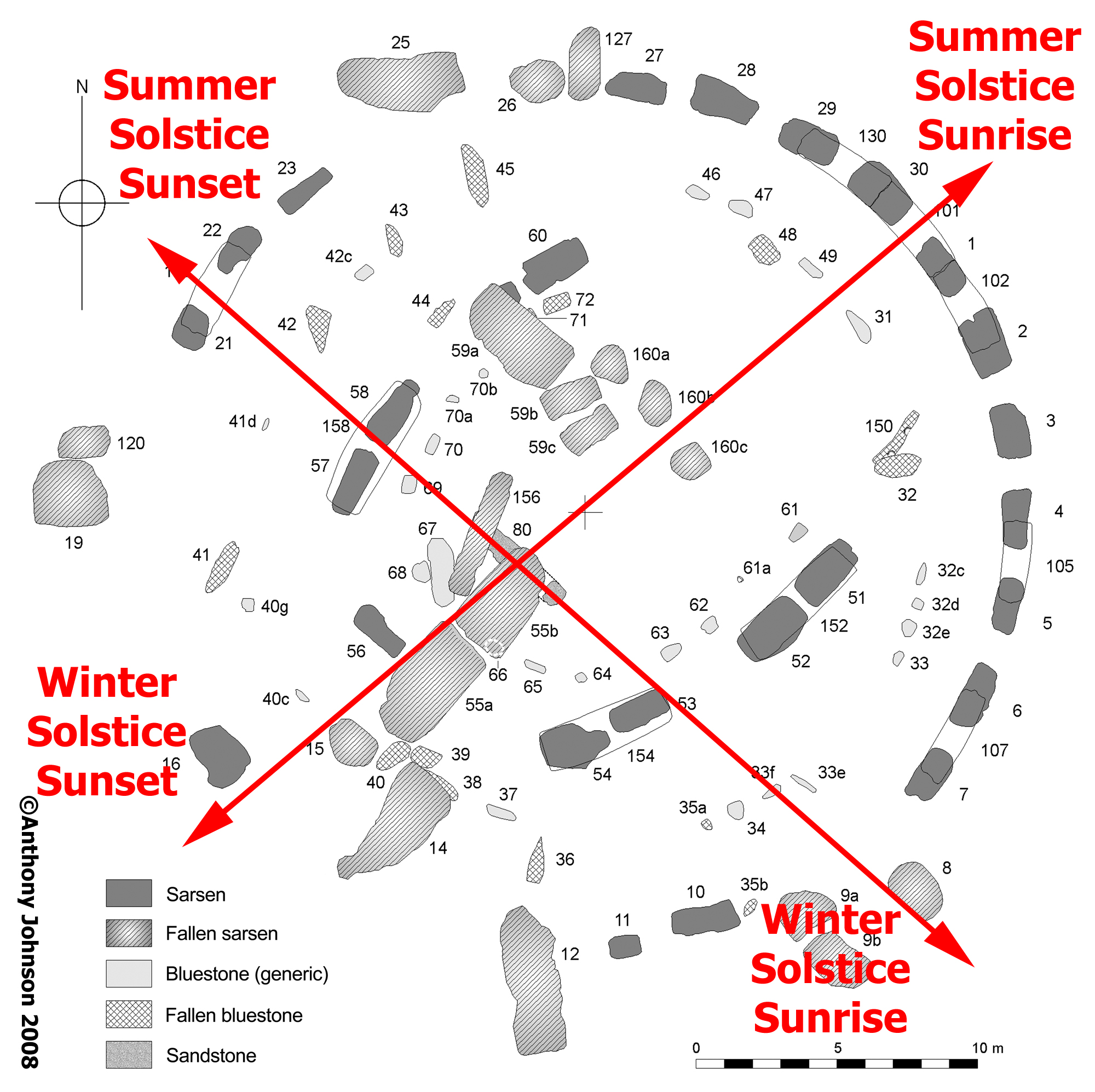
The Station Stone rectangle alignments

We moderns rediscovered this in the 1960s (see the article C.A. "Peter" Newham and the Station Stone Rectangle).

I realise that I am indulging in a huge amount of speculation here (but why not, it's fun!), but is it possible that a culture having a fascination with the sky and the movements of the Sun and Moon took it upon themselves to embark on the establishment of a monument at a location where they'd be able to bring the Sky to Earth with a supremely elegant design, using small locally sourced sarsen boulders to define the required rectangle?

Would they, perhaps, have brought a founding "anchor" stone from their ancestral homeland with them?

Where might they have installed it? Perhaps in line with the weird ridges and stripes in the landscape that pointed to the directions of the winter solstice sunset and summer solstice sunrise?

Perhaps where Atkinson suggested, in the stone hole immediately southwest of the later tallest trilithon?

Extract from "Stonehenge in its Landscape" Cleal et al 1995

Context for the extract from "Stonehenge in its Landscape"

Perhaps they set it upright but twisted it a bit so that its face could be sighted along in the direction of winter solstice sunrise and summer solstice sunset, while also being lit by the rising summer solstice and setting winter solstice Sun. A neat way to encode four directions with one stone.

Atkinson noted, having excavated around the Altar Stone in its present position, that one end had:

"clearly been dressed to an oblique bevelled outline"

which he felt might facilitate precise adjustment to its position when erected in its stonehole. 

They'd have had to twist it about 81° to the primary solstice axis - that being the angle between summer sunrise and winter sunrise at this latitude 5000 years ago.

If we accept Atkinson's suggestion that the Altar Stone once stood in the stonehole within WA 3639, then it's clear that it was subsequently moved to its present location - laying flat in front of the tallest trilithon (Stones 55, 56, 156 - now partly collapsed), most likely by the builders of the sarsen phase of the monument.

That new location is with its long axis directly under the secondary solstice alignment and with its centre being touched by the tip of the shadow of the Heelstone at summer solstice sunrise (see articles The Secondary Solstice Axis and The Shadow of the Heelstone)

We could imagine that relocating a stone of such pre-eminence on the site would have been controversial, even if its intended new position and orientation was chosen to retain that special significance.

The movers may have felt the need to appease their ancestors with an offering of some kind, and Atkinson found - within the primary fill of the empty stonehole, deliberately placed - just such a candidate, a large fragment of a polished Group I Cornish-provenanced greenstone axe.

In the small hollow in the stonehole to the bottom left of the ranging pole,
the polished greenstone axe fragment found by Atkinson

The polished greenstone axe fragment found in the stonehole of WA 3639 (2nd from left)

The authors (E.D. Evens et al) of the 1962 "Fourth Report of the Sub-Committee of the South-Western Group of Museums and Art Galleries on the Petrological Identification of Stone Axes" said, of the Group I samples:

"It is most closely matched by outcrops in the Mount's Bay region near Penzance, and the rock source might well be from a land surface now submerged. The possibility of locating this site by the methods of underwater archaeology should not be overlooked."

If the Stonehenge site was chosen by the Orcadians as the ideal spot to build their ultimate soli-lunar monument, and these five stones were then established (Altar Stone and Station Stones), the possibility exists for this having been the very earliest stone settings of Stonehenge - predating both the large sarsens, the small bluestones and perhaps even the surrounding earthwork bank and ditch and its associated cremation burials.

And so it could be that it was first established prior to 3100 BCE.

These five stones are sufficient to fix the Sky to the Earth.

Everything that came later simply reinforced and enhanced the original design.

Et in Orcadia, ego.

Update: September 12th 2024

In chasing down some references, I re-found Rodney Castleden's work "The Making of Stonehenge" (Routledge Press 1993, ISBN 0-415-08513-6) in which he identified the positioning of an upright Altar Stone in WA 3639 on the primary solstice axis. I felt I ought to acknowledge that he published and developed this idea first.

Wednesday, August 14, 2024

The Scottish Stone

Here we are, in the middle of August 2024, and over 100 years of received wisdom about the source of the Altar Stone at Stonehenge has apparently just been overturned.

Ever since H. H. Thomas suggested in 1923 that the bluestones came from South West Wales, the Altar Stone has been lumped in with them. But it's not a dolerite or a rhyolite or any of the other groups of rocks that have been traced to the Preseli Hills in Pembrokeshire.

Instead, it's a greyish-green sandstone of a type Thomas suggested possibly came from the Cosheston Beds of Old Red Sandstone near Milford Haven. His identification helped to cement the idea that the bluestones had been transported by sea and that the Altar Stone had been picked up en route just at the point of embarkation on the coastal journey.

The most obviously visible section of the Altar Stone seen
between Stone 55b on the left and Stone 156 on the right

The Altar Stone (Stone 80) isn't an easy one to find at Stonehenge - unless you know the site well. It lies, prone and mostly buried in the grass, in front of and overlain by the collapsed remains of the tallest trilithon, under the exact intersection point of the two solstice axes.

The Altar Stone lies along the secondary solstice axis (WSSR -> SSSS)
and across the primary solstice axis (SSSR -> WSSS)

It is a unique monolith at Stonehenge.

For the last 20 years the Cosheston Beds provenancing has come under increasing scrutiny through the work of Ixer, Bevins and others who have applied modern geochemical, petrological and spectroscopic analysis techniques to thin section samples known to have come from it, which have sat unremarked in various museum storerooms for decades.

It's not a match for the Milford Haven Old Red Sandstones and, for a while, it looked like the Senni Beds further to the east in Wales around the Brecon Beacons might be the true source.

The high barium content (> 1025 ppm) finally ruled out the Anglo-Welsh basin in 2023, as Bevins et al said in their paper:
It now seems ever more likely that the Altar Stone was not derived from the ORS of the Anglo-Welsh Basin, and therefore it is time to broaden our horizons, both geographically and stratigraphically into northern Britain and also to consider continental sandstones of a younger age. There is no doubt that considering the Altar Stone as a ‘bluestone’ has influenced thinking regarding the long-held view to a source in Wales. We therefore propose that the Altar Stone should be ‘de- classified’ as a bluestone, breaking a link to the essentially Mynydd Preseli-derived bluestones.

If ever a large hungry cat was ever set amongst some very sleepy pigeons, this was it.

Attention turned to the areas of Old Red Sandstone further north - around the West Midlands, the North of England and - most remarkably - Scotland.

Today, 14th August 2024, a paper in Nature was published entitled "A Scottish provenance for the Altar Stone of Stonehenge" (Clarke et al) with this astonishing map showing the most likely source for the Altar Stone.

The tan-coloured areas on this map are the closest match to the Altar Stone yet found

The paper is replete with technical geological analysis, but the abstract is well worth quoting in full (my emphasis):

Understanding the provenance of megaliths used in the Neolithic stone circle at Stonehenge, southern England, gives insight into the culture and connectivity of prehistoric Britain. The source of the Altar Stone, the central recumbent sandstone megalith, has remained unknown, with recent work discounting an Anglo-Welsh Basin origin. Here we present the age and chemistry of detrital zircon, apatite and rutile grains from within fragments of the Altar Stone. The detrital zircon load largely comprises Mesoproterozoic and Archaean sources, whereas rutile and apatite are dominated by a mid-Ordovician source. The ages of these grains indicate derivation from an ultimate Laurentian crystalline source region that was overprinted by Grampian (around 460 million years ago) magmatism. Detrital age comparisons to sedimentary packages throughout Britain and Ireland reveal a remarkable similarity to the Old Red Sandstone of the Orcadian Basin in northeast Scotland. Such a provenance implies that the Altar Stone, a 6 tonne shaped block, was sourced at least 750 km from its current location. The difficulty of long-distance overland transport of such massive cargo from Scotland, navigating topographic barriers, suggests that it was transported by sea. Such routing demonstrates a high level of societal organization with intra-Britain transport during the Neolithic period.

If this is indeed true (I'm not a geologist so can't offer an informed opinion either way), then it is not an exaggeration to say that this is a discovery of truly monumental proportions whose implications are enormously far reaching.

1) The journey length is unprecedented for any large stone moving of the time

2) The societal organisation required is staggering

3) The communication network implied is astonishing

4) The motivation necessary to undertake the task had to be compelling

We now have to radically re-think our notions of how prehistoric Britain was structured - but we shouldn't be surprised by this, necessarily. There is a large body of evidence that long distance travel was not uncommon, including obvious links between Ireland, Brittany, the Scottish Isles, Denmark and Scandinavia shown by artistic styles that originated on one place before being taken up in another, embellished, modified and then passed on again.

The Ness of Brodgar in Orkney, together with the Stones of Stennes and the Ring of Brodgar indicate a highly sophisticated and organised society with a clear shared belief structure (something to do with pointing monuments at significant Solar and Lunar rising and setting events) and the ability to influence the wider mainland population.

Pottery styles emerging here made their way south and gradually supplanted local styles making "Grooved Ware" one of the most widespread and consistent fashions across much of Britain.

The very idea of "henging" (creating an encircling bank and ditch around a special space) first began on Orkney before extending south.

This also poses quite a problem for the "non-human" transport theory of how various stones made their way to Stonehenge. Where's the glacier that plucked the Altar Stone from Scotland and deposited it conveniently close to Salisbury Plain? Just the one stone please, from that location to this.

The position of the Altar Stone inside Stonehenge is clearly special (see the previous articles on this blog: The Secondary Solstice Axis and The Shadow of the Heelstone), and we've always known the stone was unique geologically.

Now we also know, at least for the moment, that it was so special it demanded an apparently superhuman effort to bring it to where it now lies.

One final question burns in my mind: just when was it brought to Stonehenge?

Monday, July 22, 2024

Using the Moon as a Proxy for the Ancient Sun

When it comes to analysing potential alignments at Stonehenge, there's one problem that always gets in the way. Well, there are several actually but the one I'm going to describe here is pretty fundamental.

The Sun, today, does not rise and set at the solstices at the same positions on the horizon that it did when Stonehenge was built.

This is due to an oddity in the way the Earth's rotational axis behaves. We're all familiar with the idea that Earth's axis is tilted away from the vertical at an angle of about 23.5° - it's in all the diagrams of the planet, it's there in every globe you've ever seen on a desk and it's why we have any seasons at all.

The archetypal desk globe with the planet's characteristic 23.5° tilt

We might imagine that it's always been 23.5°, but it hasn't. Over very long periods of around 41,000 years this angle varies from between 24.2° and 22.5° and - we assume - back again. This is called the "Change in the Obliquity of the Ecliptic" (but don't worry about terminology for now).

4,500 years ago, when Stonehenge was built, the angle of tilt was roughly 24° give or take a couple of minutes of arc. As a result the Sun at summer solstice rose and set fractionally further round to the north than it does today, and at winter solstice it rose and set fractionally round to the south than today.

The different isn't much - about a degree or so, but it really affects observations of solstice rises and sets at Stonehenge.

For example, today the Sun at summer solstice rises out of the tip of the Heelstone, but in 2,500 BCE it rose off to the left of it - as seen from the main axis of the monument between Stones 30 and 1 on the NE side.

Summer Solstice Sunrise position today and 4,500 years ago

What this means is that there is no way to make direct observations of the Sun at the solstices as it would have been seen by the builders of the monument. Instead, we have to calculate its prehistoric position (which we can do to an excellent degree of accuracy) and create mockups like the photo above to visualise how it would have looked.

(Incidentally, if you want more about what would have happened and what you would have seen at summer solstice sunrise back in the day then take a look at the article on this site called "The Shadow of the Heelstone")

Frustrating! Except there's a way around the problem thanks to the movements of the Moon.

The Sun's rising position on the eastern horizon varies throughout the year. In summer it's in the NE then it turns around at solstice and starts heading south. By the time of the winter solstice it's reached the SE before it turns back and begins its journey northwards again.

Back and forth, regular as the pendulum of a clock, and in a human lifetime the endpoints of this swing (and the corresponding ones on the western horizon for sunsets) are effectively fixed.

The Sun's annual swing along the eastern horizon from Summer Solstice (left) to Winter Solstice (right) and back

The Moon also swings back and forth along the horizon between endpoints, but it does it every month. Each month there's a northernmost limit for rising (and setting) and two weeks later a southernmost limit. NE to SE to NE to SE to NE to SE.... tick tick tick.

What's different about the Moon is that the endpoints are not fixed like those of the Sun. The furthest north and south positions move back and forth as well. Every 18.6 years these endpoints get as far apart on the eastern horizon (for risings) as they ever can do, and the Moon can rise and set way further north (and south) than the Sun can ever reach in our era.

In the animation above, the yellow diagonal lines on the far left and right are the endpoints of the Moon's swing when it reaches its maximum extent. See how they're further apart than the Sun's endpoints (the orange diagonal lines)? The one in the middle marks the Equinox.

We're at that point in the Moon's cycle now, in 2024/25. It's called the Major Lunar Standstill. It's a poor label since it's not the same sort of "standstill" than the Sun experiences at the solstices, but we're stuck with the name. Never mind.

As always the Moon still keeps swinging along the horizon from day to day over the course of a month so it can rise anywhere between the endpoints of the swing. It's just that the endpoints are further north and south than the Sun's can ever be today. I know I just said that, but it's a critical point!

So what does this mean?

It means that if you pick your moment, you can find the Moon rising and setting at the points on the horizon where the Sun of 4,500 years ago did, so you can therefore use the Moon as a "proxy" for that ancient Sun and can directly observe how things would have looked when Stonehenge was built.

The only difference is that it's the Moon you're looking at rather than the Sun. Happily, they both appear the same size in the sky and it's less damaging to the eye to stare at the Moon :-)

Back in the late 1990s/early 2000s, Prof. Gordon Freeman of the University of Alberta - who'd spent years doing direct observations on site at Stonehenge of solstices - proposed a remarkable idea.

He suggested there was a secondary solstice axis that ran from Winter Solstice Sunrise to Summer Solstice Sunset and that there was a deliberate sightline through the stones that made use of a notch in the edge of Stone 58 coupled with the edge of Stone 53 on the opposite side of the monument. This combination created a "peephole" of sorts that was directed at Coneybury Hill where the ancient Winter Solstice Sun would have risen.

View through the Notch in Stone 58 whose open side is closed by the edge of Stone 53
to frame a very specific spot on Coneybury Hill

(For more detail on this idea, see the article on this site called "The Secondary Solstice Axis")

On July 21st 2024, the Moon rose very close to the same position that the ancient Winter Solstice Sun once did, so here was an opportunity to attempt a direct observation of Gordon's idea - was his sightline valid? By calculation, it definitely is but a chance to observe the Moon proxying for the Sun along this line was not to be missed.

Unfortunately I wasn't able to gain permission to do the observation from within the monument itself, although if all goes well I might be able to do so during one of the next times things align in the same way, so I had to try and get the data from a position out in the landscape on the projection of the alignment to the NW up towards the Cursus Barrows.

The horizon was perfectly clear and at 21:55:42 BST (20:55:42 UT) the first gleam of the Moon's upper limb appeared behind Stonehenge.

First gleam of the Moon - that tiny orange blob just left of centre on the horizon

By 21:58:52 BST, it had reached half-orb and I was getting excited.

3m 10s after first gleam things are looking promising

A little under four minutes later, the alignment fell into place.

The Moon acting as proxy for the ancient Winter Solstice Sun

It is extremely difficult to get into exactly the right spot for a shot like this - I don't have a differential GPS system to give me sub-centimeter accuracy, so I had to rely on eyeballing the monument in daylight through binoculars to get into the best position I could, so I may be a couple of metres to the left or the right of the ideal spot.

I'm certainly higher up in elevation than I would be at the monument, so the Moon appears above the horizon from this vantage point whereas it'd be resting on it otherwise.

Nevertheless, this is an excellent result and shows that it's definitely worth repeating the observation from within Stonehenge itself.

I did notice other photographers around - one actually on the visitor path next to Stonehenge - but none of them were in the right spot to get the desired (for the purposes of checking the alignment) photo. I'm sure they got fabulous images of the Full Moonrise with these hoary old stones beneath, and I look forward to seeing them.

My photos are somewhat grainy (old camera), but they're worth far more to me - and potentially to future researchers of the ancient astronomical sightlines at Stonehenge - than a pretty shot of Moonrise.

Well done for spotting this one in the first place Gordon, you are an inspiration.

Saturday, July 20, 2024

Major Lunar Standstill July 19th 2024

At Moonrise on the 19th July 2024, the Moon was very close (within a quarter of a degree) to its maximum southerly declination in its 18.61 regression of the lunar nodes cycle.

I'd booked to go in to Stonehenge on the late evening "Special Access" session, in order to try and improve on my photo from July 9th 2006 of the Moonrise in line with the northeastern side of the Station Stone rectangle.

July 9th 2006 Major Lunar Standstill - 18 years and 10 days ago

(In the mid-1960s, Peter Newham and Gerald Hawkins had independently suggested that the long sides of the Station Stone rectangle were aligned to the southernmost moonrise and northernmost moonset at the lunar standstill - see this article for the background to Newham's work.)

In the intervening 18+ years, English Heritage have placed a marker at the approximate position of where Station Stone 94 once stood (the Station Stone is no longer present, but its stonehole has been found through archaeology). There is a slight inaccuracy in its position (perhaps half a meter off), but it serves as a useful reference.

Moonrise was timed for 20:41 BST (19:41 UT) but the trees of Luxemborough Plantation on the SE horizon delay the Moon's appearance by around 5 minutes.

I set up my camera so that I was in line with the marker for SS94 and the (still present, though slumped) Station Stone 91 on the opposite side of the monument.

Initial photo on the alignment from SS94 marker to SS91.
Features of other visitors pixellated for privacy.

I knew I was further to the southwest of my 2006 position directly over SS94 (a spot which I'd then chosen by estimating the centre of the area inscribed by the bank of the North Barrow), so was expecting the Moon's position at appearance to be somewhat different to then, relative to the treeline.

With the camera taking a shot automatically every 15 seconds, I spent the next few minutes over the rope a couple of metres to the NE to try and spot the first gleam of the 97% waxing gibbous Moon over the treetops. Fortunately, there was no cloud cover at the horizon at all - which wasn't the case back in 2006.

And then, at 20:46:55, I spotted it peeping out of Luxemborough Plantation's trees. Rats! It was too far south (to the right) for my camera to have caught it - and would be blocked by the large sarsens of the NE side of the outer circle. I grabbed the tripod and quickly moved the camera to catch the Moonrise.

Off-alignment by about 2m to the NE with the Moon's upper limb just appearing.
The shot has been contrast enhanced to improve visibility.

OK, so this is somewhat annoying! First gleam over the true horizon would definitely have been visible from my original spot if there were no trees in the way. We really ought to cut a path through Luxemborough Plantation to restore this sightline.

Back home, I decided that it would a useful exercise to montage these two shots using the treeline as the reference to see what it would have looked like in an ideal world. The fractional parallax introduced by moving 2m NE off-alignment is tiny since the trees are a considerable distance away, so it's worth doing.

Here's the result.

Montage of original shot in the alignment position with the off-alignment photo,
using the treeline as the registration reference.

All very well, but how can I tell where the horizon (sans trees) would be? I can guess, but long experience of carrying out observations at Stonehenge has taught me that subtleties in both the shapes of the stones and the horizon profile are important and need to be considered.

Happily, due to the work of David Hoyle (www.standingstones.org) there is an excellent LIDAR/DTM terrain model for the Stonehenge landscape which can be loaded into Stellarium to give a pretty accurate representation of the actual horizon profile.

This is Stellarium's view of 20:46:55 BST on the 19th July 2024:

Stellarium view of Moonrise at the same instant as the first appearance of the Moon over the trees.
The Archaeolines plug-in is being used to show the arcs of the Major Standstill Moon.

A further montage, using the Moon size and the hill at 135° azimuth as reference points, allows me to see the whole picture.

Final montage with true horizon profile and rising arc of Major Lunar Standstill.
My yellow block for SS91 may be a tad short - it was a quick guess for visualisation.

At first glance, this looks excellent - the Major Lunar Standstill southernmost Moonrise appears as if it will emerge from the intersection point of the tip of Station Stone 91 and the true horizon. I suspect my yellow block is too short, but it was a rough positional indicator I plonked in while doing these montages. It's quite a long stone (3m or so) that's slumped right over and is resting on the earthwork bank.

Remember that the Moon on the 19th July 2024 is not precisely at its southernmost extreme declination, as is evidenced by the fact that Stellarium doesn't have it centred on the green rising arc lines.

However - there's one more factor we need to consider and that's the change in the Obliquity of the Ecliptic.

Earth's rotational axis is presently tilted over at roughly 23.5° to the plane of the Earth's orbit - which is why we have seasons (and indeed solstices that mark the turning points in the year). Back when Stonehenge was built, the tilt was 24°. This additional 0.5° tilt has an impact on the rising azimuths of the Sun and Moon at their extreme north and south limits.

In this specific case, 4,500 years ago when the large sarsens at Stonehenge were erected (or 5,000 years ago for the Station Stones - that's another story!) the Moon would have appeared to rise a further 1° to the right of where we are seeing it in these photos - that's two Moon diameters.

The implication of this is serious.

It means that the northeastern edge (long side) of the Station Stone rectangle is not precisely aligned with the southernmost possible Moonrise position - by something like 1.5° to 2° in azimuth based on these photos.

If we also factor in the potential inaccuracy of the position of the marker for SS94 it gets worse still - we may be looking at an error in alignment of up to 2.5° or 5 lunar diameters!

Newham and Hawkins' suggestion that the Station Stone rectangle's long sides are exactly pointed at the southernmost moonrise (SE) and northernmost moonset (NW) is starting to seem a little off.

We know, as modern astronomers, that the chances of catching the Moon rising or setting exactly at its extremest possible declination north or south of the celestial equator are very slight. The Moon races around its orbit (and hence our sky) really quickly so everything has to come together - orbitally and weatherly - for a precise observation of the extreme to be done. That may only be possible once in a generation.

What all this serves to show is that we need to devote proper resources to researching what is actually seen at Stonehenge during these occasions of rare potential astronomical alignments.

We need to be absolutely sure that if we're going to put modern markers in the ground, that they are accurately positioned which implies confirming earlier work about stonehole positions though new archaeological digs with modern DGPS instead of relying on 1950s surveys and interpretation.

And we need to seriously consider restoring sightlines in key directions by selectively felling some trees that obscure the true horizon. Luxemborough Plantation (SE), Larkhill (NE), Normanton Gorse (SW) and Fargo Wood (NW) will all need attention.

The questions that are raised here deserve further investigation. We have the chance over the next 12 months to refine my observations as we progress though this Major Lunar Standstill season (2025 is the key year).

Or not. In which case, we'll have to wait another 18.61 years for the next opportunity to do so.

Friday, July 05, 2024

Thoughts on Bluestone Trilithons

Within the collection of bluestones at Stonehenge are several interesting examples that show distinct signs of having been part of independent, tooled, structures.

Stone 36 and Stone 150 are clearly lintels having mortise holes worked into one of each of their faces, in much the same way that the lintels of the outer sarsen circle and inner horseshoe of sarsen trilithons do.

Stone 150 is quite rounded, and lies prone in the turf in the NE quadrant of the bluestone circle but Stone 36 is far more elegant and is almost entirely buried in the southern quadrant - in fact 36 is arguably the finest dressed stone on the site.

Stone 150

Stone 36


Stone 36, having been lifted for inspection during the excavations of 1954


Stonehenge plan showing the positions of Stones 36 and 150
© Anthony Johnson, annotations by Simon Banton
https://creativecommons.org/licenses/by/3.0/deed.en

As Julian Richards writes, in "Stonehenge - The Story So Far (2nd ed.)", referring to Atkinson's lifting of Stone 36 in 1954:

Apart from its sheer aesthetic qualities, Stone 36 posed some interesting questions. Along with stone 150 it was the second bluestone lintel to be identified and there were the uprights to go with them, pillars in the bluestone horseshoe that showed signs of having originally had tenons. So Atkinson could suggest a phase of ‘tooled bluestones’ which must, as there were now two lintels, have included at least two miniature trilithons. These, on the evidence of the mortice holes in the lintels would have looked very different from the much larger sarsen examples. The lintels would have extended beyond the edges of the slender pillars on which they perched, the space between the pillars and the height of the lintel sufficient to allow people to pass through.  The remarkable Stone 36 also provided evidence that this was not a short-lived structure. One of its mortice holes was surrounded by a shallow depression, presumably a carefully worked seating for the upright on which it sat, and within this hollow the surface of the stone appeared worn, even polished. This did not appear to be deliberate but more the result of friction, perhaps caused by the expansion and contraction of the touching stones. But such a polish would only develop very slowly, suggesting that these stones must have stood as trilithons for many years.

Could these two bluestone miniature trilithons have been the archetypes that eventually gave rise to much larger echoes of similar design in the enormous sarsen trilithons?

If so, then what could have been the intent behind the original creation of the bluestone versions? And where were they erected? Clearly not close to the current positions of 36 and 150 since they are remote from their supposed companion uprights which are components of the inner bluestone horseshoe arrangement and which carry the battered down remnants of tenons on their upper surfaces.

These are all repurposed stones - the bluestones have been rearranged a number of times in prehistory - and 150 in particular has been used, finally, as a pillar of the bluestone circle which was oriented so that its mortise holes would not be visible from the interior of the monument.

Bluestones have a remarkable capacity for being used as lithophones - "rock gongs" if you like. When found at their outcrops in the Preseli Hills in South West Wales, experimentally striking them with a rubber mallet or a deer antler will soon discover that certain ones that will "ring" like a bell.

They have to be positioned just right - balanced without being buried in the ground so that they can resonate when struck. The following video shows my attempts at getting a note out of a number of examples in 2023.


If there were two bluestone trilithons at some point in Stonehenge (transported there having been dismantled from an earlier monument in Preseli, perhaps), could the design have been in an effort to support two appropriate stones above the ground so that they could be easily "rung"?

What are the implications of such a suggestion? Is there an acoustic aspect to the use of Stonehenge that has been hinted at by a number of other researchers? One which employed the bluestones?

Are the bluestone trilithons in fact engineered sound sources? Maybe the "voices" of the stones were thought to have been in some way special in their own right, and bringing them to sing at the site of the future Stonehenge was important for an unknowable (to us) reason.

Given that the final arrangement of the bluestones at Stonehenge has them all either fallen, half-buried, or deeply embedded in the chalk (in the case of the upright ones) it seems that if they did have an original acoustic purpose then this was subsequently either forgotten or discounted by the people who incorporated them into the much later monument - even if they did echo their form in the horseshoe of enormous sarsen trilithons.

Sunday, May 12, 2024

Stone 11 Shadow Effect

Stone 11 is the mysteriously half-height, half-width upright in the southern quadrant of the outer sarsen circle at Stonehenge.


Plan of Stonehenge indicating position of Stone 11

Stone 11 seen from the south

Several suggestions have been made to explain its curious dimensions - that the builders ran out of bigger stones, that it's a reused lintel, that it marks a division of the 30 uprights into three groups of 10 (the other marker being Stone 21) for calendrical reasons...

The 2012 Antiquity paper "Stonehenge Remodelled" (Darvill, T. et al. (2012) ‘Stonehenge remodelled’, Antiquity, 86(334), pp. 1021–1040. doi:10.1017/S0003598X00048225) offers:

...stone 11 (south) is narrower and shorter than the others perhaps to somehow mark the southern entrance (or it may even have been a later replacement).

None of those explanations have ever felt entirely satisfactory to me.

Recently I was watching Dr. Terence Meaden's video presentation to the 2024 Megalithomania Conference, on the topic of Pytheas the Greek's voyage to Britain and Thule.

Terence is always interesting and has had enlightening things to say about megalithic structures for decades. It was he that pointed out, for instance, that the Heelstone casts a shadow that penetrates into the centre of Stonehenge on the Summer Solstice (see "The Shadow of the Heelstone" on this site for more info).

While he was explaining his hypothesis that Stone 11 is of reduced height to represent "half" in the count of sarsens in the outer circle - ie that the circle conceptually held 29.5 stones rather than 30, and so could be used as a lunar calendar count, twelve times round it making 354 days then continuing the count on to Stone 11 would bring the day tally up to 365 and hence one solar year - he put up this diagram from his 2017 paper "Stonehenge and Avebury: Megalithic shadow casting at the solstices at sunrise":

Fig. 7 from "Stonehenge and Avebury: Megalithic shadow casting at the solstices at sunrise"
Journal of Lithic Studies (2017) vol. 4, nr. 4, p. 39-66 doi:10.2218/jls.v4i4.1920

Terence points out that the shadow of Stone 11 falls on Stone 40 at Winter Solstice Sunrise, and suggests that the male Stone 11 deliberately interacts with the female Stone 40 in this way.

Those familiar with his work will recognise this as a common theme in his research - phallic upright stones casting shadows onto recumbent receiving stones at key times in the year.

The next image in his presentation gave me goosebumps.

Stone 11 just after sunrise near Winter Solstice with the Sun at its rising azimuth of 2500 BCE

The shadow of Stone 11 can clearly be seen clipping the fallen Stone 14's right hand end (its upper end when erect), and Stone 40 (a bluestone) is directly behind this fallen sarsen lying prone in the turf - not visible in this shot, exactly under Stone 11's shadow. But that's not what grabbed me.

The shadow of Stone 11 continues across the ground and directly intersects with Station Stone 93! This contrast-enhanced closeup of Terence's image shows it well.

Stone 11's shadow hitting Station Stone 93

For this to happen, Stone 11 has to be a very particular height and width - any wider and its shadow will not match the width of Station Stone 93, any taller and the shadow will extend well beyond 93's peak.

We have to remember to account for the shift in the Earth's axial tilt from 24° to 23.5° since 2500 BCE. 

At winter solstice 2500 BCE, the Sun reached "full orb" over Coneybury Hill at an azimuth of 130° 20':

Full orb winter solstice Sun position, 2500 BCE, from Stellarium
Full orb winter solstice Sun position, 2500 BCE

In our era, on the 27th December 2014 (when Terence's photo was taken), the Sun is at a higher altitude when it reaches this azimuth:

Sun's position on 27th December 2014 when it reaches azimuth 130° 20'

Its altitude in our era is 1° 6', back in 2500 BCE it was 0° 26' - a difference of 40' of arc. This difference puts the tip of Stone 11's shadow fractionally lower on Stone 93 now than it would have been then.

It seems likely that Station Stone 93 would have been completely and exactly engulfed by the shadow of Stone 11 cast by the full orb risen Sun at winter solstice in 2500 BCE.

Drawing this shadow line on the reference plan of Stonehenge from "Stonehenge in its Landscape" (Cleal et al, 1995), along with the secondary solstice axis identified originally by Gordon Freeman (see "The Secondary Solstice Axis" on this site) highlights their parallel nature.

Stone 11 shadow (black line) and the secondary solstice alignment (red line)

Zooming in on this, and incorporating the plan of the parchmarks for the missing stones 17, 18, 19 and 20 from "Parchmarks at Stonehenge, July 2013" (Banton, S., Bowden, M., Daw, T., Grady, D., & Soutar, S. (2014) Antiquity, 88(341), 733-739 https://doi.org/10.1017/S0003598X00050651) reveals an elegant aspect to this shadow line.

Closeup incorporating the plan of the parchmarks identifying the positions of Stones 17, 18, 19 and 20

... the shadow of Stone 11 (the black line) passes exactly through the gap where missing stone 18 and 19 would have stood (if indeed, they'd ever been erected - the jury's out on that one) - so it would not have been blocked by them.

In the end what does this mean?

It appears possible that Stone 11 was positioned and shaped to create a shadowplay effect at winter solstice when Stonehenge was built, one that targeted Station Stone 93 very precisely both in position and size.

If Stone 11 was fatter and taller, this wouldn't have worked so neatly.

All that remains to be explained is the leaning nature of Stone 11, because it is not perfectly upright.

Stone 11 leaning towards the south

... how does this affect things? Is it intentional? I'm looking at this picture and noticing that the right hand edge of the stone is almost perfectly vertical, compensating for the lean.

The investigation into that is a story for another day.

Many thanks to Terence for giving me permission to use his images.